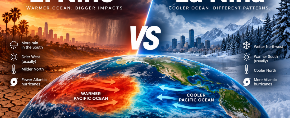
El Niño and La Niña are two of the most powerful natural climate patterns on Earth.
They begin thousands of miles away in the tropical Pacific Ocean, yet they can influence winter temperatures in New York, rainfall in California, drought across the South, hurricanes in the Atlantic, and even snowfall in the Pacific Northwest.
And right now, El Niño deserves particular attention.
NOAA’s Climate Prediction Center said on September 10 that El Niño is strengthening, with a greater than 90% chance that it will become a very strong event during fall and winter 2026–27.
So what exactly separates El Niño from La Niña?
And more importantly:
What can each one actually mean for weather in the United States?
Quick Comparison
| El Niño | La Niña | |
|---|---|---|
| Tropical Pacific | Warmer than normal | Cooler than normal |
| Trade Winds | Weaker | Stronger |
| U.S. Jet Stream | Tends to shift south | Tends to shift north |
| Southern U.S. Winter | Cooler/wetter tendency | Warmer/drier tendency |
| Northern U.S. Winter | Often milder | Often cooler in Northwest |
| Pacific Northwest | Often warmer/drier | Often cooler/wetter |
| Atlantic Hurricanes | Often less favorable | Often more favorable |
| Peak U.S. Influence | Winter | Winter |
These are typical patterns, not guarantees. Every El Niño and La Niña develops differently, and other atmospheric patterns still influence day-to-day weather.
1. What Is El Niño?
El Niño is the warm phase of a larger climate cycle called the El Niño–Southern Oscillation, or ENSO.
Normally, trade winds blow from east to west across the tropical Pacific.
Those winds push warm surface water toward Asia while colder, nutrient-rich water rises from deeper parts of the ocean near the west coast of the Americas.
During El Niño, those trade winds weaken.
Warm water shifts eastward toward the central and eastern Pacific, changing where tropical thunderstorms develop and altering atmospheric circulation far beyond the Pacific Ocean.
That eventually affects the jet stream over North America.
And that’s when people thousands of miles away begin noticing the effects.
2. What Is La Niña?
La Niña is essentially the cool phase of ENSO.
Instead of weakening, the Pacific trade winds become stronger than normal.
More warm surface water gets pushed toward Asia, while increased upwelling brings colder water toward the surface in the eastern Pacific.
The result is cooler-than-normal ocean temperatures across important parts of the tropical Pacific.
Those changes alter tropical rainfall and atmospheric circulation.
And once again, the jet stream responds.
But this time, the typical U.S. weather pattern is roughly the opposite of El Niño.
3. El Niño vs. La Niña: The Biggest Difference
The simplest way to remember the difference is:
El Niño = unusually warm tropical Pacific
La Niña = unusually cool tropical Pacific
But the ocean temperature itself isn’t what most Americans notice.
What matters is what that temperature change does to the atmosphere.
During El Niño, the Pacific jet stream tends to move farther south.
During La Niña, it tends to move farther north.
That relatively small-looking shift on a weather map can dramatically change where winter storms travel.
4. Which Brings More Rain to California?
Generally:
El Niño.
During El Niño winters, the storm track tends to shift toward the southern United States.
California and other parts of the southern U.S. therefore have increased odds of wetter-than-normal conditions.
That doesn’t mean every El Niño causes California flooding.
Some events produce much more precipitation than others.
But historically, strong El Niño events can significantly increase the chances of wet conditions in parts of California.
La Niña often pushes the storm track farther north.
That can leave Southern California and the Southwest drier.
Wetter Southern U.S. Tendency: El Niño
5. What Happens in the Pacific Northwest?
Now the pattern largely flips.
La Niña often brings a cooler and wetter winter pattern to the Pacific Northwest.
NOAA says La Niña winters typically increase the likelihood of wetter conditions in the Northwest while the southern United States becomes warmer and drier.
That can also mean better conditions for mountain snow in parts of the Northwest.
During El Niño, the Pacific Northwest more commonly experiences milder and drier conditions.
Cooler/Wetter Northwest Tendency: La Niña
6. What About the Northeast?
This is where things become less straightforward.
Neither El Niño nor La Niña means:
“New York will definitely have a snowy winter.”
Weather doesn’t work that cleanly.
ENSO changes the odds of certain broad patterns, but Northeast snowfall depends on many additional factors, including storm tracks, available cold air, and other atmospheric patterns.
NOAA specifically cautions that ENSO impacts are probabilistic rather than guaranteed.
A historical pattern might occur frequently during El Niño events without appearing during every one.
So someone in New York shouldn’t interpret a strong El Niño forecast as a specific snowfall forecast.
Think of ENSO as loading the weather dice, not determining every roll.
7. Which Is Warmer?
That depends entirely on where you live.
During a typical El Niño winter, the northern tier of the United States tends to experience milder conditions.
The southern U.S., meanwhile, can be cooler and wetter than normal.
La Niña tends to produce something closer to the reverse.
The Northwest may experience cooler conditions, while the Southeast and southern states tend to be warmer.
So there is no nationwide answer to:
“Is El Niño warmer than La Niña?”
Location matters.
8. Which Is Worse for Hurricanes?
This is another major difference.
La Niña can create atmospheric conditions that are more favorable for Atlantic hurricane development.
One reason involves vertical wind shear.
Strong wind shear can disrupt developing tropical systems.
During La Niña, upper-level wind patterns often reduce vertical wind shear over the tropical Atlantic, which can make the environment more favorable for hurricane activity.
El Niño generally has the opposite influence and can increase wind shear over the Atlantic.
Of course, ENSO isn’t the only factor controlling hurricane seasons.
Ocean temperatures, atmospheric moisture, Saharan dust, and other conditions also matter.
More Favorable Atlantic Hurricane Environment: La Niña
9. Which Is Better for Snow?
Again:
It depends where you live.
La Niña can favor colder, wetter conditions in the Pacific Northwest, potentially supporting mountain snowfall.
El Niño shifts the storm track southward and can create wetter conditions across parts of the southern U.S.
But snow requires both precipitation and sufficiently cold temperatures.
That’s why statements such as:
“El Niño means more snow”
are too simplistic.
A wetter winter can still produce less snow if temperatures are too warm.
10. How Often Do El Niño and La Niña Happen?
They aren’t annual events.
NOAA says El Niño and La Niña occur irregularly, generally every two to seven years.
Individual episodes commonly last around nine to 12 months, although some can continue longer.
There is also a third state:
ENSO-neutral.
That means neither El Niño nor La Niña conditions dominate the tropical Pacific.
So the climate doesn’t simply alternate every year between the two.
11. Why Is El Niño Getting Attention Right Now?
Because the current event is strengthening rapidly.
NOAA’s September 10 update reported sea-surface temperature anomalies exceeding 3°C above average in parts of the eastern equatorial Pacific.
The important Niño-3.4 index reached +1.8°C, while the Niño-1+2 region reached +3.4°C.
NOAA’s current assessment:
Greater than 90% chance of a very strong El Niño during Northern Hemisphere fall and winter 2026–27.
That’s unusually significant.
But even a very strong El Niño doesn’t tell us exactly what the weather will be in any particular city.
It changes probabilities.
It doesn’t write the daily forecast months in advance.
12. What Could a Strong El Niño Mean for the U.S.?
Based on historical El Niño patterns, Americans may want to watch for several broad tendencies this winter.
The southern U.S. generally has increased odds of cooler and wetter conditions.
Parts of California may have greater odds of increased precipitation.
The northern U.S. and Pacific Northwest tend toward milder conditions.
The Atlantic hurricane environment is generally less favorable during El Niño than La Niña.
But these should be treated as climate tendencies rather than promises.
NOAA emphasizes that every ENSO event is different and that other atmospheric patterns can strengthen, weaken, or alter the expected effects.
13. El Niño vs. La Niña: Which Is Worse?
Neither one is universally worse.
That’s one of the most important things to understand.
El Niño may increase flood risks in one region while easing drought somewhere else.
La Niña may improve snowfall and water supplies in one region while worsening drought in another.
Agriculture, energy demand, water supplies, wildfire conditions, fisheries, and hurricane risk can all respond differently depending on location.
The same climate pattern can be helpful in one place and damaging in another.
So the better question isn’t:
“Which is worse?”
It’s:
“Which one creates the bigger risk where I live?”
The Bottom Line
El Niño and La Niña begin with opposite temperature patterns in the tropical Pacific Ocean.
But their effects can extend around the planet.
El Niño generally shifts the U.S. winter storm track southward, increasing the odds of wetter conditions across the southern tier while bringing milder conditions to parts of the North.
La Niña generally shifts the pattern northward, increasing the odds of cooler and wetter conditions in the Pacific Northwest while making much of the southern U.S. warmer and drier.
Neither guarantees a particular winter.
But with NOAA now saying the developing El Niño has a greater than 90% chance of becoming very strong during fall and winter 2026–27, this is one climate pattern worth watching closely.
Compare with Reason.